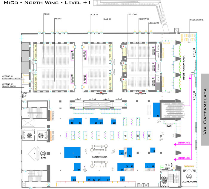
Booth 21: ASI – AGENZIA SPAZIALE ITALIANA
Website: http://www.asi.it
ASI (Agenzia Spaziale Italiana) is a government agency founded in 1988. Its purpose was to coordinate all of Italy's efforts and investments in the space sector that had begun in the 1960s. Within over twenty years' time, ASI became one of the most significant players in the world in space science, satellite technologies and the development of mobile systems for exploring the Universe. Today, ASI has a key role at the European level where Italy is the third contributor country to the European Space Agency.
|
|
Booth 1: CEOS
Website: http://ceos.org/
The Committee on Earth Observation Satellites (CEOS) ensures international coordination of civil space-based Earth observation programs and promotes exchange of data to optimize societal benefit and inform decision making for securing a prosperous and sustainable future for humankind. Its 55 agencies currently operate 131 Earth observation satellites. The CEOS exhibition will demonstrate a variety of tools and data services that enhance the use of satellite data and impact global problems.
|
|
Booth 20: CNIT
Website: http://www.cnit.it/
The Radar and Surveillance Systems (RaSS) National Laboratory is a branch of the National Interuniversity Consortium for Telecommunications (CNIT) which is a no-profit organization of 38 Italian Universities. The RaSS Lab is based in Pisa (Italy) and it carries out its research activity in the field of radar, remote sensing, applied electromagnetism, telecommunications and signal processing.
|
|
Booth 9: DIESSECHEM
Website: http://www.diessechem.com
DIESSECHEM Srl is a dynamic trading company, representing various brands of analytical instrumentation.
Diessechem is the Italian exclusive distributor of ASD Inc. (CO, USA), leading producer of field spectroradiometers for groud truthing and proximal sensing, and Headwall Inc. (MA, USA), top producer of hyperspectral imaging cameras, with the patented aberration-corrected design.
|
|
Booth 11: ENTERPRISE ELECTRONICS CORPORATION
Website: http://www.eecweathertech.com
EEC TeleSpace is a leading provider of turn-key ground stations for the real-time reception of meteorological, environmental and defense satellite data.
EEC TeleSpace is a division of Enterprise Electronics Corporation (EEC). EEC,incorporated in 1971, manufactures high quality meteorological radar systems. EEC TeleSpace leverages EEC’s core engineering capabilities for in-house antenna design, and production, seamlessly coupled with the flagship satellite data visualization and analysis software suite, PROTEUS.
Applications include; continuous weather and environmental monitoring, high-resolution satellite imagery, and disaster management.
EEC has manufactured and delivered more than 100 satellite and 1000 radar ground stations in over 90 countries worldwide.
Visit our booth to learn more about the EEC TeleSpace solution for Himawari-8 & GOES-R satellite ground stations.
|
|
Booth 8: ESA – EUROPEAN SPACE AGENCY (PLATINUM SPONSOR)
Website: http://www.esa.com
The European Space Agency (ESA) is Europe’s gateway to space.
ESA is an intergovernmental organisation, created in 1975, with the mission
to shape the development of Europe’s space capability and ensure
that investment in space delivers benefits to the citizens of Europe
and the world.
ESA will soon have 22 Member States: Austria, Belgium, the Czech Republic, Denmark,
Estonia, Finland, France, Germany, Greece, Hungary, Ireland, Italy,
Luxembourg, the Netherlands, Norway, Poland, Portugal, Romania, Spain,
Sweden, Switzerland and the United Kingdom, of whom 18 are Member
States of the EU. ESA has Cooperation Agreements with eight other Member
States of the EU and is discussing an Agreement with the one remaining
(Bulgaria). Canada takes part in some ESA programmes under
a Cooperation Agreement.
By coordinating the financial and intellectual resources of its members,
ESA can undertake programmes and activities far beyond the scope
of any single European country. ESA develops the launchers, spacecraft
and ground facilities needed to keep Europe at the forefront of global space
activities. Today, it launches satellites for Earth observation, navigation,
telecommunications and astronomy, sends probes to the far reaches
of the Solar System and cooperates in the human exploration of space.
|
|
Booth 7: GOOGLE
Website: http://www.google.com
Google Earth Engine brings together the world's satellite imagery — trillions of scientific measurements dating back over 40 years — and makes it available online with tools for scientists, independent researchers, and nations to mine this massive warehouse of data to detect changes, map trends and quantify differences on the Earth's surface. Applications include: detecting deforestation, classifying land cover, estimating forest biomass and carbon, and mapping the world’s roadless areas.
|
|
Booth 10: HARRIS
Website: http://www.exelisvis.eu
We provide desktop, cloud and mobile software solutions to help professionals across industries transform geospatial imagery and complex data into actionable information. Customers use our bespoke services and products – ENVI and IDL – to quickly and easily visualise and analyse all types of data and imagery for better, more informed decision making.
|
|
Booth 15: HEADWALL PHOTONICS
Website: http://www.headwallphotonics.com
For remote-sensing applications, Headwall produces the world’s most precise multispectral and hyperspectral imaging solutions featuring aberration-corrected optics, outstanding spatial and spectral resolution, and a very wide field of view. Headwall’s sensors are deployed aboard UAVs (lightweight and larger), fixed-wing aircraft, and satellites for applications such as precision agriculture, minerals and mining, environmental analysis, and pipeline inspection. Headwall has manufacturing locations in the United States and Europe and is ISO-9001:2008-certified. Spectral ranges include VNIR (400-1000nm); Extended VNIR (550-1700nm); NIR (900-1700nm); and SWIR (900-2500nm).
|
|
Booth 17: IEEE/GRSS
Website: http://grss-ieee.org
The Geoscience and Remote Sensing Society seeks to advance science and technology in geoscience, remote sensing and related fields using conferences, education, and other resources. The fields of interest of the Society are the theory, concepts, and techniques of science and engineering as they apply to the remote sensing of the earth, oceans, atmosphere, and space, as well as the processing, interpretation and dissemination of this information.
|
|
Booth 16: IGARSS 2016
Website: http://www.igarss2016.org
Co-hosted by the IEEE Geoscience and National Space Science Center (NSSC), China Academy of Science (CAS), the International Geoscience and Remote Sensing Symposium 2016 (IGARSS 2016) will be held from 10th to 15th July, 2016, at the National Convention Center in Beijing, China. The theme of the Congress is “Advancing the Understand of Our Living Planet”, by which we want to stress the physical insights in Remote Sensing. Technical papers on this theme will be accepted and specially acknowledged. Other papers in all fields of Remote Sensing will also be welcome.
|
|
Booth 2: JAXA – JAPANESE AEROSPACE EXPLORATION AGENCY
Website: http://global.jaxa.jp/
Since JAXA was launched in October 2003, it consistently performed numerous activities within the aerospace field. JAXA technologies are now globally regarded as excellent as its has performed challenging tasks like successful rocket launches, activities for the International Space Station, and development and operation of satellites and probes.
In January 2015, the new Basic Plan for Space Policy determined the three objectives of Japan space policy: i) secure national security in space; ii) promote space utilization by private sectors; and iii) strengthen and maintain the foundation of the space industry, science and technology. The new role of JAXA is to be the core organization providing technological support for all governmental development and utilization of space projects., JAXA will incorporate the aims of the National Research and Development Agency. Its activities will assume a broader perspective and incorporate research over a wide range of areas of expertise, aiming at maximizing the results of research and development conducted throughout Japan. This will include taking a leading role in the development of technology, and uncovering true values to help solve problems within the society. JAXA intends to accelerate all research in this respect.
|
|
Booth 22: METASENSING
Website: http://www.metasensing.com/
MetaSensing is an innovative company providing proprietary sensors for data acquisition and post-processing services. MetaSensing offers a broad range of radars operating at different frequency bands. MetaSensing sensors are compact, high-resolution and cost-effective. Each sensor is customised in order to fulfil the customers' needs. MetaSensing has introduced a novel ground based solution for monitoring instable natural elements and critical artificial structures. The FastGBSAR is a non-invasive remote sensing tool for continuous deformation monitoring of large coverage areas, a compact and easy-to-install sensor that can operate even under harsh working conditions. The MetaSensing Ku-band radar for structure monitoring and terrain stability is an excellent example of the versatile and customizable MetaSensing products.
|
|
Booth 23: NASA
Website: http://www.nasa.gov
NASA Earth System Science conducts and sponsors research, collects new observations from space, develops technologies and extends science and technology education to learners of all ages. We work closely with our global partners in government, industry, and the public to enhance economic security, and environmental stewardship, benefiting society in many tangible ways. We conduct and sponsor research to answer fundamental science questions about the changes we see in climate, weather, and natural hazards, and deliver sound science that helps decision-makers make informed decisions.
|
|
| Booth 6: PASCO CORPORATION |
|
Booth 4: RIKOLA LTD
Website: http://www.rikola.fi
Rikola Ltd. offers small and lightweight hyperspectral camera for UAVs. This innovative product is a frame-based spectral system providing true snapshot images. The frame based approach enables an easy image stitching for the mosaics with high resolution images. The solution doesn’t need IMU for its operations, which makes the system low cost and low weight. The camera enables handheld use with computers too. Rikola offers also OEM multichannel- and LED-modules as well as miniature spectrometers.
|
|
Booth 12: SI IMAGING SERVICES
Website: http:/www.si-imaging.com
SI Imaging Services (SIIS) was founded in April 2014 as a subsidiary of Satrec Initiative (SI) with the mission of “Fair Access to Space”. SIIS, which is specialized company in satellite imaging services, is exclusive distributor of KOMPSAT-2 (1.0 m optical), KOMPSAT-3 (0.7 m optical), and KOMPSAT-5 (1.0 m SAR) satellites imagery and also distributes DubaiSat-2 (1.0 m optical) imagery worldwide. SIIS has established the global business network with more than 60 resellers and partners. In the capability of providing both optical and radar imagery as well as the collaborative business with worldwide network, SIIS offers better and fair imaging services to customers.
|
|
Booth 5: SKYE INSTRUMENTS
Website: http://www.skyeinstruments.com
Skye Instruments Ltd have been designing and manufacturing instrumentation for Remote Sensing, Environmental Monitoring, Plant and Agricultural Research since 1983. We have a range of Remote Sensing instruments for ground, tower and airborne installations, which include Eddy Covariance/Flux Towers & UAV’s.
Our Multi-Spectral sensors include wavelengths for LANDSAT, SPOT, NOAA, AVHRR, MODIS, plus many more Earth observation satellites. Please visit us at booth #8 to see our product range and to discuss your requirements. We look forward to seeing you at IGARSS 2015.
|
|
Booth 13: SPACE FLIGHT LABORATORY
Website: http://www.utias-sfl.net
Satellites built by the Space Flight Laboratory (SFL) push the performance envelope and disrupt the traditional cost paradigm. Mission performance and data achievements are striking relative to the available budget. SFL celebrates over 39 cumulative years of operational heritage in MOST, CanX-2, NTS, AISSat-1, AISSat-2, CanX-4, CanX-5, and BRITE space astronomy satellites. Additional satellites launching soon include EV9, AISSat-3, NORSAT-1, GHGSat-D, NEMO-AM, CanX-7, M3MSat, and the next generation Earth observation satellite, NEMO-HD – a compact 72kg satellite capable of multispectral, high-definition imaging and video with up to 2.8m resolution. SFL arranges launches worldwide and operates a global ground station network.
|
|
Booth 18: SPECTRA VISTA CORPORATION
Website: http://www.spectravista.com
Building on over 20 years of experience in the design and manufacture of Field Portable Spectroradiometers and Airborne Imaging Spectrometers, SVC is demonstrating the flagship SVC HR-1024i spectroradiometer. This is one of a family of fully integrated instruments providing the highest quality data while including an internal camera, built-in GPS and second Bluetooth radio for communication with external sensors. Now, all the important spectral, positional, time, and image information is collected coincidentally and stored in one place. This is ideal for conducting agricultural, geological, environmental, research and critical for ground truthing efforts. The SVC HR-1024i is being used by a number of top level government institutions for demanding meteorological and inter-calibration applications. Please drop by booth #18 so we can discuss your application
|
|
Booth 3: ST Electronics (Satcom & Sensor Systems) Pte Ltd
Website: http://www.stee.stengg.com, http://www.agilspace.com
ST Electronics (Satcom & Sensor Systems) delivers innovative, broadband wireless communication and sensor solutions that enhance connectivity and safety globally. Together with its US related satellite communications company, VT iDirect, the company serves a wide range of industry, covering telecommunications, government and defence, maritime, oil and gas, broadcast and enterprise organisations and is a leading supplier of Very Small Aperture Terminals (VSATs), microwave communications and RF equipment. The company also specialises in the design, development and production of advanced earth observation satellites and is poised to contribute to the future development of satellite and sensor technologies. Through its subsidiary ST Electronics (Satellite Systems) set up in 2011, it offers a comprehensive suite of satellite and earth observation solutions to its customers worldwide.
|
|
|
Booth 19: VITO
Website: https://vito.be
VITO’s (Flemish Institute for Technological Research) Remote Sensing Unit, with more than 80 specialists, is active in multiple remote sensing activities such as developing new remote sensing systems, sensors and platforms, processing and distribution of multiple spaceborne/airborne/UAV data and also designing several local and global applications for end-users worldwide. The main focus areas of expertise are Environment, Climate Change, Agriculture, Food Security, Water Quality and Security.
Mission: Remote sensing for the benefit of sustainable Land Use. Our offer: +80 motivated employees; In search of technological solutions; Scientifically justified advice; From satellite to RPAS remote sensing; Combined with in-situ observations; Market oriented products and services; Specialized services for crop monitoring and yield forecasting; On a local, regional and continental scale; Hyperspectral sensors and derived products and services; Unique 16-years archive of SPOT-VEGETATION and PROBA-V.
|
|
