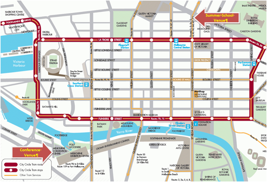
| Thursday, July 18 |
| 8:30-9:00 | Registration (RMIT University, 445 Swanston Street) |
| 9:00-9:10 | Opening |
| 9:10-10:30 | Nathan Quadros (Airborne LiDAR acquisition and validation) |
| 10:30-10:50 | Morning Tea (provided) |
| 10:50-12:10 | Suzanne Furby (Image processing for the land cover change program of a national carbon accounting system) |
| 12:10-13:30 | Lunch (on your own) |
| 13:30-14:50 | Mihai Datcu (Image information mining) |
| 14:50-15:10 | Afternoon Tea (provided) |
| 15:10-16:30 | Lorenzo Bruzzone (Multi-temporal image analysis) |
| 17:00-18:30 | Social event (Oxford Scholar Pub - 427 Swanston Street) |
|
| Friday, July 19 |
| 9:00-9:10 | Housekeeping |
| 9:10-10:30 | Jocelyn Chanussot (Hyperspectral image and signal processing) |
| 10:30-10:50 | Morning Tea (provided) |
| 10:50-12:10 | Professor Duncan Campbell (The ABCs of UAVs) |
| 12:10-13:30 | Lunch (on your own) |
| 13:30-14:50 | John Richards (Thematic mapping from SAR imagery) |
| 14:50-15:10 | Afternoon Tea (provided) |
| 15:10-16:10 | Mihai Tanase and Rocco Panciera (Calibrating airborne radar for soil-moisture extraction) |
| 16:10-16:20 | Issue of certificate, photo, and wrap-up |
 |
Lorenzo Bruzzone received the Laurea (M.S.) degree in electronic engineering (summa cum laude) and the Ph.D. degree in telecommunications from the University of Genoa, Italy, in 1993 and 1998, respectively.
He is currently a Full Professor of telecommunications at the University of Trento, Italy, where he teaches remote sensing, radar, pattern recognition, and electrical communications. Dr. Bruzzone is the founder and the director of the Remote Sensing Laboratory in the Department of Information Engineering and Computer Science, University of Trento. His current research interests are in the areas of remote sensing, radar and SAR, signal processing, and pattern recognition. He promotes and supervises research on these topics within the frameworks of many national and international projects. Among the others, he is the Principal Investigator of the Radar for icy Moon exploration (RIME) instrument in the framework of the JUpiter ICy moons Explorer (JUICE) mission of the European Space Agency. He is the author (or coauthor) of 137 scientific publications in referred international journals (93 in IEEE journals), more than 190 papers in conference proceedings, and 16 book chapters. He was invited as keynote speaker in 24 international conferences and workshops. He is a member of the Managing Committee of the Italian Inter-University Consortium on Telecommunications. Since 2009 he is a member of the Administrative Committee of the IEEE Geoscience and Remote Sensing Society. He is an IEEE Fellow.
|
 |
Professor Duncan Campbell is the Director of the Australian Research Centre for Aerospace Automation (ARCAA) with the School of Electrical Engineering and Computer Science at the Queensland University of Technology, Brisbane, Australia. He has 25 years of research leadership in control and automation. Duncan serves as Secretary on the Board of the Australian Association for Unmanned Systems (AAUS) and was the IEEE Queensland Section Chapter Chair of the Control Systems/Robotics and Automation Society Joint Chapter (2008/2009). He is the Chair of CDIO Australian and New Zealand regional group of the global CDIO collaboration in engineering education, and was President of the Australasian Association for Engineering Education in 2011. Duncan is the leader for Project ResQu, a two year, $7M collaborative research partnership between QUT, CSIRO, Boeing Research & Technology Australia, Insitu Pacific Ltd and the Queensland State Government. Project ResQu is fast-tracking research to help unmanned aircraft become airborne for routine civilian operations sooner, focusing upon both the enabling technologies and the regulatory environment.
|
 |
Jocelyn Chanussot (M'04-SM'04-F'12) received the M.Sc. degree in electrical engineering from the Grenoble Institute of Technology (Grenoble INP), Grenoble, France, in 1995, and the Ph.D. degree from Savoie University, Annecy, France, in 1998. In 1999, he was with the Geography Imagery Perception Laboratory for the Delegation Generale de l'Armement (DGA - French National Defense Department). Since 1999, he has been with Grenoble INP, where he was an Assistant Professor from 1999 to 2005, an Associate Professor from 2005 to 2007, and is currently a Professor of signal and image processing. He is conducting his research at the Grenoble Images Speech Signals and Automatics Laboratory (GIPSA-Lab). His research interests include image analysis, multicomponent image processing, nonlinear filtering, and data fusion in remote sensing.
Dr. Chanussot is the founding President of IEEE Geoscience and Remote Sensing French chapter (2007-2010) which received the 2010 IEEE GRS-S Chapter Excellence Award. He was the co-recipient of the NORSIG 2006 Best Student Paper Award, the IEEE GRSS 2011 Symposium Best Paper Award, the IEEE GRSS 2012 Transactions Prize Paper Award and the IEEE GRSS 2013 Highest Impact Paper Award. He was a member of the IEEE Geoscience and Remote Sensing Society AdCom (2009-2010), in charge of membership development. He was the General Chair of the first IEEE GRSS Workshop on Hyperspectral Image and Signal Processing, Evolution in Remote sensing (WHISPERS). He was the Chair (2009-2011) and Cochair of the GRS Data Fusion Technical Committee (2005-2008). He was a member of the Machine Learning for Signal Processing Technical Committee of the IEEE Signal Processing Society (2006-2008) and the Program Chair of the IEEE International Workshop on Machine Learning for Signal Processing, (2009). He was an Associate Editor for the IEEE GEOSCIENCE AND REMOTE SENSING LETTERS (2005-2007) and for Pattern Recognition (2006-2008). Since 2007, he is an Associate Editor for the IEEE TRANSACTIONS ON GEOSCIENCE AND REMOTE SENSING. Since 2011, he is the Editor-in-Chief of the IEEE Journal of Selected Topics in Applied Earth Observations and Remote Sensing.
|
 |
Suzanne Furby is a member of the Terrestrial Mapping and Monitoring research group in CSIRO Mathematics, Informatics and Statistics, based in Perth, Western Australia. She coordinated the remote sensing program to monitor land cover change across the continent used in the National Carbon Accounting System. The group continues to work with the Department of Industry, Innovation, Climate Change, Science, Research and Tertiary Education to develop further land cover change products for the NCAS and for natural resource management applications more generally. Suzanne is a key member of the team that is supporting Indonesia to build a National Carbon Accounting System similar to that of Australia and has worked with demonstration teams in China.
|
 |
Rocco Panciera received the M.S. degree in environmental engineering from the University of Trento, Italy, in 2003. In 2009 he obtained his Ph.D. degree in Environmental Engineering from the University of Melbourne, Australia, with a thesis on the effect of land surface heterogeneity on the accuracy of spaceborne soil moisture retrieval using passive microwave techniques. He then worked at the University of Melbourne as a Research Fellow within the Soil Moisture Active Passive (SMAPEx) project for algorithm development for NASA's SMAP mission. In this role he conducted two large scale field experiments in South-Eastern Australia including airborne active and passive microwave sensors. From January 2011 he has been based at the Cooperative Research Centre for Spatial Information (CRC-SI), Melbourne, Australia, where he is employed under the Superscience Fellowship from the Australian Research Council (ARC). In this role he has been working on techniques to estimate fine-resolution soil moisture by use of L-band and X-band Synthetic Aperture Radar (SAR) measurements. He has also been investigating the use of Light Detection and Ranging (LiDAR) techniques for fine-resolution retrieval of surface roughness characteristics in agricultural areas. His current field of interest is the retrieval of soil moisture from airborne and spaceborne SAR observations.
|
 |
Nathan Quadros: Nathan Quadros is an airborne LiDAR specialist working at the Cooperative Research Centre for Spatial Information. He has advised and managed the acquisition of numerous LiDAR projects in Victoria, Australia and the Pacific. His recent research has focused on vertical datum transformations, LiDAR validation and acquisition standards. Nathan has a particular interest in the acquisition of bathymetric LiDAR, and topographic LiDAR when it is used for modelling sea-level rise, coastal inundation and catchment flooding.
|
 |
John Richards is a Fellow of the Australian Academy of Technological Sciences and Engineering, a Fellow of the Institution of Engineers Australia and a Life Fellow of the IEEE.
He has held the positions of Master of University House at the Australian National University, Deputy Vice-Chancellor and Vice President of the ANU, and Dean of the College of Engineering and Computer Science. In the1980s he was foundation Director of the Centre for Remote Sensing at the University of New South Wales.
John is an Emeritus Professor of the Australian National University and the University of New South Wales, Visiting Professor at the Harbin Institute of Technology, China, Visiting Professor of the Chinese Academy of Sciences, and President of the International Society for Digital Earth.
|
 |
Mihai A. Tanase received the engineering diploma in forestry from Stefan cel Mare University,Romania, in 1999; the diploma in economy from the Bucharest Academy of Economic Studies, Romania, in 2004; the M.Sc. degree in environmental management from the International Centre for Advanced Mediterranean Agronomic Studies, France, in 2007; and the Ph.D. degree in geography from the University of Zaragoza, Spain, in 2010.
Since 2011, he holds a post doctoral position at the University of Melbourne/CRC for Spatial Information through the ARC Super Science Fellowship program. He is a Principal Investigator for ESA -ERS, DLR - TerraSAR/Tandem-X, JAXA- ALOS PALSAR2 and CSA-SOAR research programs and participated in the JAXA K&C Initiative as a Co-Investigator. He is interested in the use of remote sensing for vegetation characterization. His current activity is focused on SAR, InSAR and PolSAR data for ?re severity estimation, vegetation recovery monitoring and the retrieval of bio-geophysical parameters of forests and agricultural crops. Dr. Tanase was the recipient of the IEEE GRSS- IGARSS Symposium Interactive Prize Paper Award in 2010.
|


 IGARSS13
 @IGARSS2013