The theme for this year’s meeting is “International Cooperation for Global Awareness,” and our emphasis for the meeting will be to reinforce the value of working together to find global solutions to our most pressing problems in Earth observation and remote sensing. On behalf of the IGARSS 2017 organizing committee, we are pleased to announce the Technology, Industry and Education (TIE) Forum, a non-traditional session track that will focus on these three facets and its relation to remote sensing.
These sessions will present topics not typically covered during the conference, and we encourage audience participation through panels, and extended Q&A sessions to increase interactivity and engagement. We hope that you will join us in Room 200 at IGARSS 2017 for the TIE Forum.
Boon Lim
TIE Forum Chair, IGARSS 2017
Jet Propulsion Laboratory
| MO3.TIE: GEO and Global Awareness |
|---|
| Session Type: Oral |
| Time: Monday, July 24, 13:40 - 15:20 |
| Location: Room 200 |
| Session Chairs: Tony Milne and Melba Crawford |
| 13:40 - 14:20 |
| MO3.TIE.1: Group on Earth Observation – GEO and Global Awareness |
| Barbara Ryan, GEO Secretariat Director |
Barbara J. Ryan, is the Secretariat Director of the Intergovernmental Group on Earth Observations (GEO) in Geneva, Switzerland. GEO is comprised of nearly 100 Member States, the European Commission, and 90 international scientific and technical partner organizations. Previously Ryan was an Associate Director for Geography at the USGS, and in 2008 became Director of the World Meteorological Organization’s Space Programme. Under GEO leadership, millions of satellite images and other Earth observation data have been made available to the general public at no charge, allowing scientists, planners and policy makers to make better-informed decisions on problems that transcend political boundaries. GEO works to address critical issues in agriculture, biodiversity, climate change, disaster planning, energy, health and water. |
| 14:20 - 14:40 |
| MO3.TIE.3: GEO Cold Regions (CRI) and IEEE Pole to Pole Initiatives |
| Yubao Qui, RADI, CAS, Vanessa Aellen, GEO Secretariat, Tony Milne, IEEE Ad Hoc Committee |
Yubao Qui is an Associate Professor in the Institute of Remote Sensing and Digital Earth, Chinese Academy of Science (RADI CAS). Tony Milne is a Visiting Professor of Geography and Remote Sensing at the University of New South Wales in Sydney and a Member of the GEO Programme Board. Climate change occurring in the Polar Regions will have significant impact in terms of maritime navigation, exploration and exploitation, environmental stress and human society globally. The aim of the GEOCRI is to develop a user driven approach to Cold Regions information services and foster collaboration for improved earth observations and information sharing of cold regions data on a global scale. The IEEE Ad Hoc Committee on the North and South Poles was established to help IEEE Societies and volunteers understand both the challenges and opportunities to contribute to the technical, scientific and research needs of Polar Regions. |
| 14:40 - 15:00 |
| MO3.TIE.4: GFOI – Global Forest Observation Initiative and Future Challenges |
| Brian D. Killough, NASA Langley Research Center |

Brian Killough is currently responsible for the Committee on Earth Observing Satellites (CEOS) Systems Engineering Office (SEO). Forests play an important role in regulating the Earth's climate, conserving biodiversity and water resources, and influencing social and economic conditions. To understand the change in forests it is essential to obtain comprehensive and continuous observations of global lands. To this end, the Group on Earth Observations (GEO) has taken the initiative in investigating how to improve the provision of satellite and ground data for forest monitoring in the framework of the Global Forest Observation Initiative (GFOI). GFOI specifically supports REDD+ countries to develop their national forest monitoring systems and associated emissions measurement, reporting and verification procedures. |
| 15:20 - 15:40 |
| MO3.TIE.5: AfriGEOSS - GRSS Soil Moisture and Agricultural Support Project |
| Adriano Camps and Maria Piles, Barcelona Expert Center, ICM/CSIC, UPC, Spain |
GRSS in collaboration with African Researchers and ESA scientists working at the Barcelona Expert Center(BEC), initiated an AfriGEOSS Soil Moisture and Agricultural Outreach Support Project for assisting African national organizations. The major objectives of the ongoing project are (1) to map the spatio-temporal soil moisture patterns over the African continent from 2010 to 2017; (2) for selected regions in South Africa use MODIS data to downscale the SMOS coarse-resolution measurements of soil moisture to 1 km and, (3) make high resolution soil moisture maps over Southern Africa available through the BEC distribution and visualization services. |
| MO4.TIE: Earth Observation, Sustainable Goals and the United Nations 2030 Program |
|---|
| Session Type: Oral |
| Time: Monday, July 24, 16:20 - 18:00 |
| Location: Room 200 |
| Session Chairs: Melba Crawford and Tony Milne |
| 16:20 - 17:00 |
| MO4.TIE.1: Sustainable Development Goals and Earth Observation |
| Lawrence Friedl, Argyro Kavvada, NASA’s Earth Science Division, USA |
Lawrence Friedl is the Director of the Applied Sciences Program within NASA’s Earth Science Division. He has been with the NASA Applied Sciences Program since 2002. Friedl is a Co-Chair of the interagency U.S. Group on Earth Observations (US-GEO) and represents the United States on the international Group on Earth Observations (GEO) and leads efforts to advance Earth Observation initiatives in order to realize the objectives of the UN 2030 Agenda for Sustainable Development. The United Nations 2030 Agenda for Sustainable Development adopted in September 2015 provides a universal development agenda for all countries and stakeholders to use as a blueprint of action for people, the planet and prosperity. The agenda is anchored by seventeen (17) Sustainable Development Goals (SDG); associated targets and a global indicator framework. Collectively, these elements enable countries and the global community to measure, manage, and monitor progress on economic, social and environmental sustainability. |
| 17:00 - 17:20 |
| MO4.TIE.3: CEOS -Earth Observation Data Provision for GEO and Sustainable Development |
| Alex Held, CSIRO, Canberra, Australia |
Alex Held is the Past Chair (2016) of the Committee on Earth Observation Satellites (CEOS).He is Principal Scientist and Research Group Leader of the Landscape Observation and Simulation Group of the Australian CSIRO Land and Water Division. CEOS (the Committee on Earth Observation Satellites) is made up of 55 space agencies committed to coordinating satellite earth observation programs and to sharing data for a more sustainable and prosperous future. CEOS ensures international coordination of civil space-based earth observation programs and promotes exchange of data to optimize societal benefit and inform decision making for securing a prosperous and sustainable future for humankind. CEOS supports GEO stakeholders with Earth observation data, information products, and related expertise. CEOS Agencies supported the establishment of GEO, and CEOS has since made continuous and growing contributions to GEO through a wide range of Earth observation initiatives. |
| 17:20 - 17:40 |
| MO4.TIE.4: Datacubes — Geospatial Information and the UN’s Sustainable Development Goals |
| Stuart Minchin, Chief, Environmental Geoscience, Geoscience Australia; Alex Held, CSIRO, Canberra, Australia |
Stuart Minchin Stuart Minchin is currently head of Australia’s delegation to the United Nations Committee of Experts on Global Geospatial Information Management, and the Australian representative to the Group on Earth Observation (GEO). The United Nations Committee of Experts on Global Geospatial Information Management (UN-GGIM) recognises that earth observation and the derived geospatial information will have an essential role in both assisting Member States in achieving those goals, and to monitor progress over time. Geoscience Australia's Data Cube is a new way of organising, analysing and managing large amounts of data collected from earth observation satellites and one which facilitates efficient interrogation of stacked time series imagery. As everything happens somewhere, location provides a unique link between where that activity is occurring and the statistical, demographic and environmental information that can be used to monitor that activity. |
| 17:40 - 18:00 |
| MO4.TIE.5: Global Activities of the Geoscience and Remote Sensing Society (GRSS) |
| Paul Rosen, Jet Propulsion Laboratory, USA; Anthony Milne, University of New South Wales, Australia and Melba Crawford, Purdue University, USA |
Paul Rosen is the current Director of Global Activities for GRSS. Melba Crawford and Tony Milne are former Directors of Global Activities. In 2010 GRSS Administrative Committee established a Global Initiative Taskforce to recommend policies and procedures that would help GRSS extend its scientific, technical and professional services more effectively into developing countries, with the objectives of enabling GRSS to support and nurture its global membership. Three sub-committees were established to progress these activities in Asia, Africa and Latin America. The tasks of the sub-committees included developing a strategic plan for GRSS activities within each region, including Chapter building and membership promotion, and which sought to identify organizations and institutions within these regions that could collaborate with GRSS to advance remote sensing technical, scientific and capacity building initiatives. |
| TU1.TIE: Author Education: How to publish IEEE papers |
|---|
| Session Type: Oral |
| Time: Tuesday, July 25, 08:00 - 09:40 |
| Location: Room 200 |
| Session Chairs: Alejandro C. Frery, Paolo Gamba and Antonio Plaza |
|
There will be an official IEEE Author Education Event at IGARSS 2017 during the TIE forum, on Tuesday TU1.TIE and Thursday TH1.TIE. Come and get advice and input on how IEEE publishes your papers, what to do in organizing your manuscripts, what things to avoid in your papers and what will make you paper the most acceptable. The material will be based on previous classes taught by the present VP of the IEEE Publications and Products Service Board (PSPB), Sheila Hemani and by its previous VP Gianlucca Setti. The class will be given by one of the current editors of the GRSS publications (Geoscience and Remote Sensing Letters, Journal of Selected Topics in Applied Earth Observations and Remote Sensing, Transactions in Geoscience and Remote Sensing, and Geoscience and Remote Sensing Magazine). Come and learn how to publish your papers. More information can be found at: https://www.ieee.org/publications_standards/publications/authors/author_education 
Alejandro C. Frery received the B.Sc. degree in Electronic and Electrical Engineering from the Universidad de Mendoza, Mendoza, Argentina. His M.Sc. degree was in Applied Mathematics (Statistics) from the Instituto de Matemática Pura e Aplicada (IMPA, Rio de Janeiro) and his Ph.D. degree was in Applied Computing from the Instituto Nacional de Pesquisas Espaciais (INPE, São José dos Campos, Brazil). He is currently the leader of LaCCAN -- Laboratório de Computação Científica e Análise Numérica, Universidade Federal de Alagoas, Maceió, Brazil. Since 2013 he is the Editor-in-Chief of IEEE Geoscience and Remote Sensing Letters. His research interests are statistical computing and stochastic modelling. 
Paolo Gamba is Professor of Telecommunications at the University of Pavia, Italy, where he leads the Telecommunications and Remote Sensing Laboratory and serves as Deputy Coordinator of the Ph.D. School in Electronics and Computer Science. He received the Laurea degree in Electronic Engineering “cum laude” from the University of Pavia, Italy, in 1989, and the Ph.D. in Electronic Engineering from the same University in 1993. He served as Editor-in-Chief of the IEEE Geoscience and Remote Sensing Letters from 2009 to 2013, and as Chair of the Data Fusion Committee of the IEEE Geoscience and Remote Sensing Society from October 2005 to May 2009. Currently, he serves as GRSS Vice President for Professional Activities, Chair of the Chapters Committee, and Chair of the Symposium Awards Committee. He has been the Guest Editor of special issues of IEEE Transactions on Geoscience and Remote Sensing, IEEE Journal of Selected Topics in Remote Sensing Applications, ISPRS Journal of Photogrammetry and Remote Sensing, International Journal of Information Fusion and Pattern Recognition Letters on the topics of Urban Remote Sensing, Remote Sensing for Disaster Management, Pattern Recognition in Remote Sensing Applications. He published more than 130 papers in international peer-review journals and presented more than 250 research works in workshops and conferences. 
Antonio Plaza is the Head of the Hyperspectral Computing Laboratory at the Department of Technology of Computers and Communications, University of Extremadura. His main research interests comprise hyperspectral data processing and parallel computing of remote sensing data. He has authored more than 500 publications, including more than 150 journal papers (more than 100 in IEEE journals), 20 book chapters, and over 250 peer-reviewed conference proceeding papers. He has guest edited 9 special issues on hyperspectral remote sensing for different journals. Dr. Plaza is a Fellow of IEEE “for contributions to hyperspectral data processing and parallel computing of Earth observation data.” He is a recipient of the recognition of Best Reviewers of the IEEE Geoscience and Remote Sensing Letters (in 2009) and a recipient of the recognition of Best Reviewers of the IEEE Transactions on Geoscience and Remote Sensing (in 2010), for which he served as Associate Editor in 2007-2012. He is also an Associate Editor for IEEE Access, and was a member of the Editorial Board of the IEEE Geoscience and Remote Sensing Newsletter (2011-2012) and the IEEE Geoscience and Remote Sensing Magazine (2013). He was also a member of the steering committee of the IEEE Journal of Selected Topics in Applied Earth Observations and Remote Sensing (JSTARS). He is currently serving as the Editor-in-Chief of the IEEE Transactions on Geoscience and Remote Sensing journal. |
| TU2.TIE: 2017 IEEE GRSS Women in STEM Forum |
|---|
| Session Type: Panel |
| Time: Tuesday, July 25, 10:40 - 12:20 |
| Location: Room 200 |
| Session Chairs: Mariko Burgin and Lori Bruce |
At this year’s IGARSS, for the first time, we are organizing the Technology, Industry and Education (TIE) Forum, a non-traditional session that will address themes typically absent from technical conferences. As part of the TIE Forum, the Women in STEM Forum is organized to promote diversity, inclusion, and career success in the Geoscience and Remote Sensing Society (GRSS) that benefit all IGARSS attendees, but is particularly focused on women and minority attendees.
Women remain underrepresented in the STEM workforce. While efforts have been made through education, funded initiatives, and the emergence of non-profit discussion, progress has been slow. The technical and engineering sectors are still male dominated and the pipeline for future talent is currently insufficient to meet future needs. In the US today, only 14% of all engineers and 25% of all IT professionals are women. Although women make up 55% of all college and graduate students, only 18% of computer science graduates are female, according to the US Bureau of Statistics.
The IGARSS Women in STEM Forum will feature three highly accomplished women in STEM from a mix of backgrounds and with diverse career paths. Each speaker will have the opportunity to give a short presentation of 15-20 minutes on being a woman in STEM, enabling diversity, lending privilege, and work/life balance followed by an open discussion and extended Q&A.
We are inviting you to join the Women in STEM Forum. Come to learn, be inspired, and network!

Dr. Louise Prockter is the Director of the Lunar and Planetary Institute in Houston Texas. Dr. Prockter has been involved in robotic planetary missions throughout her career. She served as an Imaging Team associate on the Galileo and Near-Earth Asteroid Rendezvous (NEAR) missions; was Deputy Project Scientist and a Co-Investigator on the MESSENGER mission, and served as the Instrument Scientist for the spacecraft’s dual imaging system; was a Deputy Project Scientist for the Europa Clipper mission, and is currently a Co-Investigator on that mission’s camera team. Dr. Prockter earned her Ph.D. in Planetary Geology from Brown University. She has participated in numerous NRC advisory panels, including the Committee for Planetary Exploration (COMPLEX), the Space Studies Board, and the Planetary Decadal Survey, as well as NASA’s Planetary Science Subcommittee. Dr. Prockter’s scientific research focuses on using remote sensing to study the geomorphology and structural tectonics of icy satellites and other solar system bodies. She is a Fellow of the Geological Society of America.
Mrs. Sandra Alba Cauffman currently serves as the Deputy Director of the Earth Science Division, in the Science Mission Directorate at the National Aeronautics and Space Administration (NASA) Headquarters. She provides executive leadership, strategic direction, and overall management for the entire agency’s Earth Science portfolio, from technology development, applied science, research, mission implementation and operation.
Prior to joining NASA HQ, Mrs. Cauffman worked at the Goddard Space Flight Center (GSFC) for 25 years serving on a variety of roles. She served as the Deputy Systems Program Director for the Geostationary Operational Environmental Satellite (GOES)-R Series, a multi-billion dollar operational geostationary weather satellite program developed in partnership with the National Oceanic and Atmospheric Administration (NOAA). Before returning to the GOES program for the third time in her career, Mrs. Cauffman was the Deputy Project Manager for the Mars Atmosphere and Volatile Evolution (MAVEN) Mission, a NASA mission to the red planet, which launched on November 18, 2013 and arrived at Mars on September 21, 2014. MAVEN is providing a comprehensive picture of the present state of the upper atmosphere and ionosphere of Mars and the processes controlling them to determine how loss of volatiles to outer space in the present epoch varies with changing solar conditions.
She served as the Project Manager (PM) for the Gravity and Extreme Magnetism Small Explorer (SMEX) (GEMS). In June 2009, GEMS was one of two missions selected for implementation competing on the 2008 SMEX Announcement of Opportunity (AO). GEMS was an Astrophysics mission using X-Ray polarimetry to probe the structure and effects of the formidable magnetic field around black holes, magnetars, dead stars. Previously, Mrs. Cauffman was the Assistant Director for Flight Projects Directorate since August 2004. As assistant Director, Mrs. Cauffman helped maintain technical and administrative oversight for the Directorate.
Mrs. Cauffman served as the Deputy Project Manager for the GOES-R Series Program. Before becoming the GOES-R Deputy Project Manager, Mrs. Cauffman served as the Instrument Systems Manager for GOES-R, overseeing the research, development and implementation of multi-million dollar instruments directed toward exploration of the Earth's environment, weather prediction, charged particle detection, advanced data collection and search and rescue techniques.
Before joining GOES (again), Mrs. Cauffman served as the Project Formulation Office (PFO) Office Chief, where she was responsible for planning, implementing, and coordinating all activities related to the development of feasible mission concepts, requirements generation and formulation of new projects to be implemented such us Global Precipitation Mission (GPM), Landsat Data Continuity Mission (LDCM), Solar Dynamic Observatory (SDO), Constellation X, and Laser Interferometer Space Antenna (LISA).
Mrs. Cauffman worked on GOES as an Instrument Manager supporting the design, development, fabrication, test and launch and on-orbit checkout of the GOES-I/M and N/P SXI and SEM instruments. Mrs. Cauffman joined NASA in 1991, when she started as the Ground Systems Manager for the Satellite Servicing Project, where she supported missions such as Hubble Space Telescope (HST) First Servicing Mission, Upper Atmosphere Research Satellite (UARS), and Explorers Platform (EP)/Extreme Ultraviolet Explorer (EUVE). Before her NASA life, Mrs. Cauffman worked for Engineering and Economics Research (EER).
Mrs. Cauffman has been awarded the NASA Exceptional Achievement Medal and she is a two-time recipient of the NASA Outstanding Leadership Medal. She is also a four times recipient of the NASA Acquisition Improvement Award. She is a Senior Fellow on the Council for Excellence in Government. She received a B.S. in Physics, a B.S in Electrical Engineering and a M.S. in Electrical Engineering, all from George Mason University. Mrs. Cauffman was born in Costa Rica and is fluent in Spanish.

Dr. Makenzie Lystrup is responsible for Ball’s new business activities for NASA, NOAA, and other civil U.S. government and non-government organizations. This includes flight missions, instruments, and technology development programs across all areas of science. Examples of recent programs secured under her leadership range from the NASA Imaging X-Ray Polarimetry Explorer (IXPE) astrophysics mission to NASA Earth science advanced technology development programs for the future of Sustained Land Imaging. She leads strategic planning for Civil Space at Ball and is involved in a number of cross-company endeavors.
Dr. Lystrup previously served as Director for Space Sciences in Ball’s Washington, D.C. operations office and worked in the U.S. House of Representatives as a Congressional Science Policy Fellow. In her time working in Congress, she handled issues ranging from technology and privacy to national defense to trade.
As a planetary scientist and astronomer, Dr. Lystrup’s scientific work has been in understanding the relationships between a planet’s atmosphere and its surrounding space environment. Her work investigating the Jupiter, Saturn, and Uranus systems has employed ground-based and space-based telescopes and remote sensing observations using ultraviolet and infrared imaging, spectroscopy, and spectropolarimetry. Dr. Lystrup was a National Science Foundation Astronomy & Astrophysics Postdoctoral Research Fellow and earned her PhD in astrophysics at University College London.
Dr. Lystrup is committed to service in the science and space communities. She is a member of the Board of Directors of CO-LABS and is Vice Chair of the science advisory board of the Commercial Spaceflight Federation. Other service has included National Academies of Sciences committees, conference committee leadership, and leading the American Astronomical Society’s planetary science policy committee.
| TU3.TIE: IEEE GRSS Membership and Technical Committees |
|---|
| Session Type: Oral |
| Time: Tuesday, July 25, 13:40 - 15:20 |
| Location: Room 200 |
| Session Chairs: Xiaolong Dong and Irena Hajnsek |
This session will showcase the IEEE Geoscience and Remote Sensing Society (GRSS) who is the sponsor of the International Geoscience and Remote Sensing Symposium. The GRSS fields of interest of are the theory, concepts, and techniques of science and engineering as they apply to the remote sensing of the earth, oceans, atmosphere, and space, as well as the processing, interpretation and dissemination of this information.
The session will kick off with a welcome address from the president of the IEEE GRSS, Dr. Adriano Camps. A presentation will then be made by the current GRSS Membership Committee Chair, Dr. Xiaolong Dong on the various benefits of membership. Finally the Dr. Irena Hajnsek will introduce and showcase the various technical committees of the IEEE GRSS, established to actively promote discussion and advances in areas of member technical interests. Activities of the Technical Committees include networking within the scientific topic, organization of thematic workshops, education of young professionals, organization of special sessions at IGARSS along with hosting a committee meeting open to all IGARSS participants.
The mission of the Earth Science Informatics Technical Committee (ESI TC) is to advance the application of informatics to geosciences and remote sensing, to provide a venue for ESI professionals to exchange information and knowledge, and to give technology advice to major national and international ESI initiatives.
The FARS committee mission is to provide technical assessments, guidance and recommendations regarding matters of frequency sharing and interference between remote sensing and other uses of the radiowave spectrum.
The IFT Technical Committee’s vision is “to foster international cooperation in advancing the state-of-the-art in geoscience remote sensing instrumentation and technologies that improve knowledge for the betterment of society and the global environment”. The Committee’s mission is to facilitate, engage and coordinate GRSS members and the communities-at-large to: assess the current state-of-the-art in remote sensing instruments and technology, identify new instrument concepts and relevant technology trends, and recognize enabling technologies for future instruments. The committee actively promotes and provides insight to institutions and industry on remote sensing instrument and technology development.
The Image Analysis and Data Fusion Technical Committee serves as a global, multidisciplinary, network for geospatial data fusion, connecting people and resources. It aims at educating students and professionals, and at promoting best practices in data fusion applications.
The GSIS TC provides a forum for technical and programmatic discussion and consultation among national space agencies, research institutions and other spaceborne IS data providers. Goals of the GSIS TC are to share information on current and future spaceborne imaging spectroscopy (“hyperspectral”) missions, and to seek opportunities for new international partnerships to the benefit of the global user community.
The mission of the Modeling in Remote Sensing Technical Committee (MIRS TC) is to serve as a technical and professional forum for advancing the science of predicting remotely sensed observations from first principles theory. The MIRS TC addresses the technical space between basic electromagnetic theory and data collected by remote sensing instruments. It focuses on models and techniques used to take geometric, volumetric and material composition descriptions of a scene along with their EM (e.g., scattering, absorption, emission, optical BRDF, dielectric properties, etc.) attributes and then predict for a given remote sensing instrument the resulting observation.
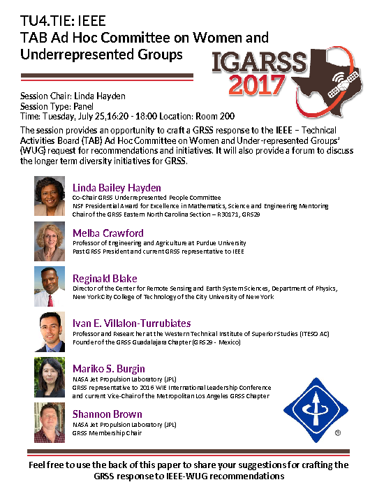
| TU4.TIE: IEEE TAB Ad Hoc Committee on Women and Under-represented Groups |
|---|
| Session Type: Panel |
| Time: Tuesday, July 25, 16:20 - 18:00 |
| Location: Room 200 |
| Session Chairs: Linda Hayden and Melba Crawford |
The session provides an opportunity craft the response of GRSS to the new 2016 IEEE - Technical Activities Board (TAB) Ad Hoc Committee on Women and Under-represented Groups (WUG) initiative. An IEEE-TAB committee member will give an overview of the charge to their committee, which includes identifying IEEE processes that are barriers to representation and inclusion and to suggest improvements.
| WE2.TIE: Remote Sensing Industry Panel |
|---|
| Session Type: Panel |
| Time: Wednesday, July 26, 10:40 - 12:20 |
| Location: Room 200 |
| Session Chair: Thomas Adang |
IGARSS will host a panel with members from the remote sensing industry, to discuss their ever evolving role in geoscience and remote sensing. Invitees are: Airbus, Ball Aerospace, Capella Space, Descartes Labs, DigitalGlobe, Planet, and PCIGeomatics. Moderated by Dr. Thomas Adang of the Aerospace Corporation, the panel will discuss how their work in remote sensing addresses global challenges, and how their work ‘makes a difference’. The panel will provide a unique opportunity for the audience of IGARSS – students, educators, scientists, engineers, and the general public – of the importance of industry in remote sensing.
Dr. Thomas C. Adang is the Assistant General Manager, National Oceanic and Atmospheric Administration (NOAA) Programs Directorate for The Aerospace Corporation. He serves as the Senior Technical Advisor to the Under Secretary of Commerce for Environmental Observations and Predictions (and Deputy NOAA Administrator), provides technical and managerial leadership to Directorate personnel, and manages the NOAA Programs line of business within the Civil Systems Group, a division of The Aerospace Corporation.
Dr. Adang joined The Aerospace Corporation in 2000 as a Senior Project Engineer supporting the National Reconnaissance Office (NRO). In 2002, he established the Silver Spring Program Office supporting the NOAA Satellite and Information Service and served as that office’s Systems Director. In 2005, Dr. Adang began a two year federal appointment with NOAA, serving in a Senior Executive Service position as the NOAA Technical Director for Integrated Observations and Data Management. While supporting NOAA, he also was instrumental in establishing the intergovernmental Group on Earth Observations (GEO) and the U.S. Group on Earth Observations (USGEO), serving as Senior Technical Advisor to the ad hoc GEO Secretariat until its formal establishment and transition to Geneva, Switzerland. In 2007, Dr. Adang moved to New Mexico as Senior Technical Advisor to the Director, Operationally Responsive Space (ORS) Office, Kirtland AFB, NM, where he was responsible for providing technical leadership and strategic messaging support to the Department of Defense ORS Office as it developed and provided responsive space capabilities to Joint Force Commanders and other users.
 Dr. Steffen Kuntz – Airbus
Dr. Steffen Kuntz has more than 30 years of experience in remote sensing applications and Geographic Information Systems. Working since 1993 in industry his activities included for instance product marketing and project management in Europe, the Near East, Russia, India, Indonesia, South America and Africa. He was responsible for the acquisition and management of various Earth observation and navigation application projects in the fields of forestry, agriculture, water management, land use planning, disaster management, illegal logging, communication, etc. In addition, he worked as a consultant for private and public customers in various technical and scientific studies and in business and product development.
Joining Infoterra GmbH in 2002 he acted as Senior Advisor for geo-information services, and was responsible for market development, scientific studies and the management of large international projects, for instance in the framework of the European Kopernicus initiative. From 2012 onwards he worked in the Corporate Development Department of Astrium GEO Information Services responsible for institutional relations and climate change programs. In June 2013 he moved to the Future Missions Department of Airbus Defence & Space (former Astrium Satellites) in Friedrichshafen, to support end-to-end satellite development and related services and in satellite export programs.
In 1997 he was nominated Assistant Professor for Remote Sensing and GIS at the University of Freiburg, Faculty for Forestry and Natural Resources Management. In 2005 he became Associated Full Professor. His teaching activities in Freiburg comprise introductory courses in remote sensing and GIS, forest inventories and ground truth assessment as well as special courses introducing REDD+, using optical and RADAR technology. In addition he gave master courses as guest lecturer at the University of Münster, Germany, in Greece at the Aristotle University of Thessaloniki and the Mediterranean Agronomic Institute of Chania, Crete and at the Universities of Paraná and Viçosa, Brazil.
 Dr. Shelley Petroy – Ball Aerospace
Dr. Shelley Petroy is the Advanced Systems Manager for Earth Sciences with Ball Aerospace in Boulder, Colorado. She received her BS in Geology from UNC-Chapel Hill, MS in Planetary Geology from Arizona State and her PhD in Remote Sensing/Earth Sciences from Washington University. Her three decade career in Earth and Space Sciences began at the Smithsonian Institution, where she studied the moons of Jupiter using Voyager data, through NASA, and into the aerospace industry, where she spent many years with Ball Aerospace developing earth science mission concepts with PIs from around the world. Returning to her passion of field work and remote sensing, Dr. Petroy worked for several years at NEON (the National Ecological Observatory Network) as manager of the Data Products team. As that project is nearing completion of construction and moving into operations, Dr. Petroy returned recently to Ball Aerospace, picking up where she left off in earth science technology and mission development.
 Mr. William Woods – Capella Space
While at Stanford I studied both synthetic aperture radar (SAR) and radio occultation with Drs. Howard Zebker and Ivan Linscott. My doctoral program was funded by the radioscience experiment (REX) onboard NASA's New Horizons Mission to Pluto. Within my program I studied studied the retrieval of atmospheric pressure and temperature estimates from radio occultation data. I withdrew from the doctoral program at Stanford in order to occupy role of CTO and Co-founder at Capella Space.
 Dr. Nathan Longbotham – Descartes Labs
Dr. Nathan Longbotham received the Ph.D. degree in Aerospace Engineering Sciences from the University of Colorado in 2012 with a remote sensing specialization. He received the M.S. degree in Optical Science and Engineering from the University of New Mexico in 2008 and the B.S. degree in Physics (magna cum laude; university scholar; presidential scholar; Fred J. Barton departmental award) from Abilene Christian University in 2001.
He is currently a remote sensing scientist at Descartes Labs in Santa Fe, New Mexico. Descartes is providing the missing geospatial link to making satellite imagery useful by providing immediate and convenient access to worldwide imagery through the Descartes Labs Platform. Nathan’s work at Descartes Labs focuses on improving and standardizing data normalization across all sensors served through the Descartes Labs Platform. Prior to joining the company, he worked on a variety of both software and hardware based remote sensing technologies including computational information extraction, tunable ultraviolet lasers for holographic data storage drives, and Q-switched microlasers for LIDAR systems.
 Mr. Victor Leonard – Digital Globe
Recognized thought leader. More than four decades in research, development and operation of space, air and ground remote sensing systems for defense, intelligence, civil and commercial applications. Wide variety of management, research, development, engineering and operations positions with the U. S. Air Force, the Boeing Company, the Central Intelligence Agency (CIA), Resource21 LLC and DigitalGlobe relating to IMINT, SIGINT and MASINT systems and commercial remote sensing.
As Senior Fellow at DigitalGlobe, Mr. Leonard provides thought leadership on a broad range of domains: Established comprehensive corporate R&D roadmap and program, defining more than 40 remote sensing imagery and information projects essential to company growth and increased profitability. Authored numerous white papers and presentations for internal and external decision makers, including seminal art-of-the-possible concepts. Defined overall concept, requirements and programmatics for an imagery streaming service that makes commercial imagery available to remote users within minutes to an hour of collection. Defined overall concept and requirements for a game-changing space and ground system that efficiently assesses mission utility of each imagery pixel and accurately estimates absolute surface reflectance. Defined overall concept and requirements for a next generation cloud-based imagery and information products and services platform. Defined the overall concept and requirements for commercial secure operations. Invited representative for American high resolution commercial imagery at US and Allied Space Wargames since 2001.
 Dr. Joe Mascaro – Planet
Joe Mascaro is a tropical ecologist and Director of Academic Programs at Planet, a San Francisco-based aerospace company that operates the largest fleet of Earth-imaging satellites. Joe works with universities and individual investigators to utilize Planet’s unprecedented imaging resources to enhance primary research and education, improve forest monitoring and conservation, expand food security, and promote ecological resilience for some of the world’s most vulnerable communities.
 Mr. Arnold Hougham – PCIGeomatics
Arnold Hougham is a high-tech industry veteran with almost 30 years of experience in academic, government, and private sectors. Mr. Hougham holds Bachelor’s and Master’s degrees in Geography from the University of Waterloo. He was a junior faculty member at the University of Saskatchewan, and learned remote sensing image processing at the Saskatchewan Research Council. He then headed the remote sensing facility for the Government of Alberta.
PCI brought him on as a Sales Representative in 1989, where he worked his way up through the ranks before departing PCI Geomatics as VP Sales and Marketing. Mr. Hougham joined Electronics Workbench (EWB) in order to manage their international reseller network. EWB was then acquired by National Instruments (NASDAQ: NATI) where he worked mainly in the Academic Division in direct sales management and channel sales and marketing management for an 8 year period, overseeing 45% compound annual growth in the academic reseller channel from 2009 to 2012. Mr. Hougham re-joined PCI Geomatics in June 2013 as Vice President, Sales and Marketing.
| WE3.TIE: Remote Sensing Industry Session |
|---|
| Session Type: Panel |
| Time: Wednesday, July 26, 13:40 - 15:20 |
| Location: Room 200 |
| Session Chairs: Marwan Younis and Fabio Pacifici |
|
This session will provide members of the remote sensing industry an opportunity to showcase their products and capabilities. Invitees include, but are not limited to: Airbus, Ball Aerospace, Descartes Labs, DigitalGlobe, Infoterra, Nanoracks, Planet, SPIRE and UrtheCast. 
Marwan Younis, received his B.Sc in electrical engineering from the University of Baghdad, Iraq in 1992 and the Dipl.-Ing. (M.Sc.) and Dr.-Ing. (Ph.D.) degree in electrical engineering from the Universität Karlsruhe (TH), Germany, in 1997 and 2004, respectively. He is currently the Director of Corporate Relations for the IEEE-GRSS. From 1998 to 2004, he was a research scientist with the Institut für Höchstfrequenztechnik und Elektronik, Universität Karlsruhe (TH). Since 2005 he has been with the Microwaves and Radar Institute of the German Aerospace Center (DLR), Oberpfaffenhofen, Germany. He is the author and co-author of about 100 conference papers and more than 20 reviewed publications. His research fields include synthetic aperture radar (SAR) systems, SAR performance, digital beamforming for radar, synchronization of bistatic SAR, forward looking radar, and antennas. |
Fabio Pacifici received the Ph.D. degree in GeoInformation from Tor Vergata University, Rome, Italy, in 2010. He also received the Laurea Specialistica and Laurea degrees in telecommunication engineering from the same University, in 2006 and 2003, respectively. He is currently a Sr. Staff Scientist with DigitalGlobe, Inc., Longmont, Colorado, USA. He collaborated as Visiting Scientist with the Department of Aerospace Engineering Sciences, University of Colorado, Boulder, between 2005 and 2009. His research activities include processing of remote sensing images, data fusion, feature extraction, pattern recognition, and analysis of multi-angular and multi-temporal data. His interests include classification and change detection techniques for urban remote sensing applications using very high spatial resolution optical and/or synthetic aperture radar imagery, with special emphasis on machine learning. |
Panelists |
| 13:40 - 13:54 |
| WE3.TIE.1: Airbus |
|
The presentation will start with a short overview on the new organizational structure of Airbus and will show our heritage and the current satellite related product and service portfolio of Airbus Defence and Space - Earth Observation, Navigation and Science (ENS). As a response to the global challenges of space industry today in the domain of Earth observation Airbus has identified several strategic fields for action: continuity in the provision of 1) "premium data ", (2) intelligence and digital services, (3) massive intelligence, and (4) improved data analytics. In the talk examples will be given how Airbus addresses them and what it will mean for the EO community. |
| 13:54 - 14:08 |
| WE3.TIE.2: Ball Aerospace |
|
Ball Aerospace pioneers discoveries that enable our customers to perform beyond expectation and protect what matters most. Founded at the beginning of the space age as a subsidiary of Ball Corporation, we have built on our legacy of integrity, technical expertise and value to help customers across solutions, partnerships and opportunities. As both a spacecraft and payload developer, we have a unique understanding of instrument integration and experience delivering end-to-end systems. Come learn more about where Ball has been, from our legacy earth science missions including imaging (Landsat 8), microwave (the GPM Microwave Imager: GMI), and lidar (CALIPSO) - to what we are working on now, such as TEMPO - a revolutionary instrument that will deliver accurate North American pollution observations with high resolution and frequency for the first time. And see where Ball plans to go, as the earth science remote sensing market rapidly evolves into a multitude of different platform options (Methane monitoring from aircraft, high resolution imaging from balloons) and small sensor/satellites (thermal infrared measurements from a cubesat and incredibly small imaging small sensors for the future of sustained land imaging). |
| 14:08 - 14:22 |
| WE3.TIE.3: Capella Space |
|
Space Radar in the 21st Century |
| 14:22 - 14:36 |
| WE3.TIE.4: Descartes Labs |
|
The promise of remotely sensed geospatial data has always been the ability to gather and interpret data at scales unavailable to more direct observation. However, this vision has been hampered by the large size and complexity of geospatial data. Limitations in the availability of compute resources, a lack of normalized data access, and the level of expertise required to correctly handle the various data manipulations create an unfriendly environment for anyone looking to utilize the large amounts of data that are available. Descartes Labs is addressing these issues through its geospatial platform. The main advantage of the Descartes Labs approach is a cloud native API over cloud object storage with access to practically infinite storage. Additionally, the Descartes Labs Platform standardizes data access, spectral processing levels, and metadata formats for all sensors yielding a uniquely scalable geospatial solution. Leveraging this technology, Descartes Labs has shown the ability to deploy satellite derived products on a global scale. This presentation will outline the advantages of this approach to scaled compute on geospatial data and highlight example applications that are enabled by this type of system. |
| 14:36 - 14:50 |
| WE3.TIE.5: Digital Globe |
|
The Move to Higher Levels of Mission Utility and Value thru Broader Remote Sensing Modalities |
| 14:50 - 15:04 |
| WE3.TIE.6: Planet |
|
Planet is an integrated aerospace and data analytics company that operates the largest fleet of Earth-imaging satellites. With more than 140 cube-sats now in orbit, Planet now has the capability to image the entire land surface of the Earth on a daily basis. Due to investments in cloud storage and computing, approximately 75% of imagery collected is available to Planet’s partners within 24 hours of capture through an Application Program Interface. This unique dataset has enormous applications for monitoring the status of Earth’s ecosystems and human activity. Through our Education and Research programs, Planet has made data available for researchers in areas as disparate as human rights monitoring in refugee camps, to assessments of the impact of hydroelectric installations, to tracking illegal gold mining in Amazon forests, to assessing the status of the cryosphere. We will share early results from Planet’s research partner network, including enhanced spatial and temporal resolution of NDVI data for agricultural health in Saudi Arabia, computation of rates of illegal deforestation in Southern Peru, estimates of tropical forest carbon stocks based on data integration with active sensors, and estimates of glacial flow rates. We synthesize the potentially enormous research and scientific value of Planet’s persistent monitoring capability, and discuss methods by which the data will be disseminated into the scientific community. |
| 15:04 - 15:18 |
| WE3.TIE.7: PCI Geomatics |
|
PCI Geomatics is a world-leading developer of software and systems for remote sensing, geo-image processing, and photogrammetry. With 35 years of experience in the geospatial industry, PCI is recognized globally for its excellence in providing software for accurately and rapidly processing satellite and aerial imagery. There are more than 30,000 PCI licenses, in over 150 countries worldwide. |
| WE4.TIE: Remote Sensing Agency Session |
|---|
| Session Type: Town Hall |
| Time: Wednesday, July 26, 16:20 - 18:00 |
| Location: Room 200 |
| 16:20 - 17:00 |
| WE4.TIE.1: NOAA Satellite Observing System Architecture Studies |
| Dr. Karen St. Germain, Director, Office of Systems Architecture and Advanced Planning NOAA/NESDIS |
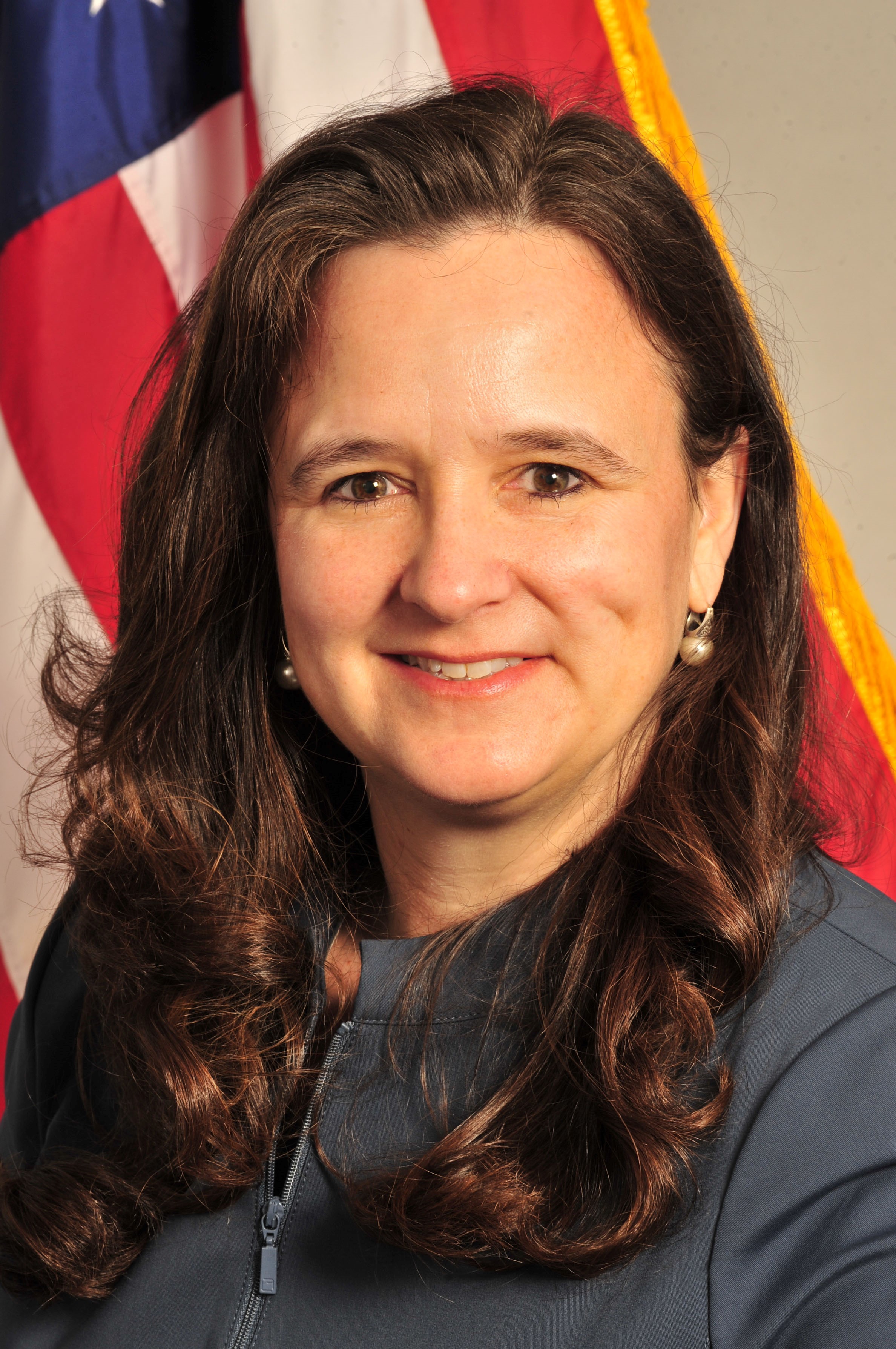
NOAA is conducting a study, the NOAA Satellite Observing System Architecture (NSOSA) study, to plan for the future operational environmental satellite system that will follow GOES-R and JPSS, beginning in approximately 2030. This is an opportunity to assess the NOAA mission value of evolutionary and revolutionary future architecture options, in terms of instruments, platforms, orbits, and business models. The NSOSA study team has developed and is currently performing cost/benefit analysis over 50 architecture alternatives, to include partner and commercial contributions that are likely to become available. At the same time, the NOAA Commercial Space Policy calls for NOAA to undertake projects as appropriate to demonstrate the viability of assimilating commercial data into the NOAA operational data stream. The NESDIS Commercial Space Activities Assessment Process calls for these demonstration projects to be completed prior to the purchase of commercial data for operational use. The Commercial Weather Data Pilot is one such project, and serves the dual roles of evaluating on-orbit commercial data to demonstrate the quality of the data and its impact to weather forecast models, as well as informing NOAA’s process for ingesting, evaluating, and utilizing commercial data in the future. Dr. St. Germain will discuss both of the ongoing efforts, and the opportunities and challenges they represent. Dr. Karen St. Germain serves as the Director of the Office of Systems Architecture and Advanced Planning (OSAAP) for NOAA’s Satellite and Information Service (NESDIS). She leads enterprise-level mission architecture development and systems engineering to enable NESDIS to become a flexible, stable and responsive civil space agency in support of NOAA’s mission. Dr. St. Germain is a leader in enterprise-level planning and multi-organizational programs of national significance. She is also an expert in major systems acquisition, with particular proficiency in transitioning new technology into operational systems. Dr. St. Germain developed a deep understanding of the NESDIS mission as NOAA’s lead for all aspects of system performance during the development of the successful Suomi-NPP system, from 2006 to 2011. In 2011, Dr. St. Germain accepted a position in the Space, Strategic and Intelligence Systems (SSI) Office, Office of the Under Secretary of Defense for Acquisition, Technology and Logistics (OUSD AT&L). There, Dr. St. Germain designed and led the successful DoD 2014 Strategic Portfolio Review for Space to develop a strategy and implementation plan for adapting to evolving challenges in the space domain. Dr. St. Germain also led the Remote Sensing and Prompt Strike Division within SSI, where she was responsible for acquisition shaping and oversight of DoD strategic missile warning and space-based environmental monitoring portfolio, and the Program Director of the Conventional Prompt Global Strike Program. Prior to her work on operational systems, Dr. St. Germain had a successful research career at the University of Massachusetts, the University of Nebraska, and the Naval Research Laboratory. Her research took her to the Arctic and Antarctic on ice-breakers, through hurricanes and tropical storms on NOAA’s P-3s, and on a snowmobile traverse of the Greenland ice sheet. She and her colleagues developed and successfully transitioned a new space-based ocean surface wind vector observation technique from airborne proof of concept to the WindSat Coriolis space borne demonstration. Dr. St. Germain holds a Bachelor of Science degree in electrical engineering from Union College (1987) and a Doctor of Philosophy degree in Electrical Engineering from the University of Massachusetts (1993). She is also a Distinguished Graduate of the National War College, National Defense University where she earned a Master of Science degree in National Security Strategy in 2013. |
| 17:00 - 17:40 |
| WE4.TIE.2: Sustainable Development Goals and Earth Observation |
| Dr. Upendra Singh, NASA Technical Fellow |
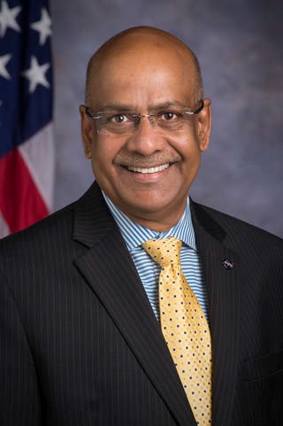
Active Optical Remote Sensing Sensors and Instrumentations for NASA’s Future Earth Science MissionsNASA is at forefront in developing active optical remote sensing technologies and unique capabilities towards space-based observations for understanding the complexities and interactions among Earth system components. The world is facing significant environmental challenges and a robust, integrated, and flexible system of observations and models are needed for understanding the short-and long term impact on the Earth system. A fundamental challenge for the coming decade is to ensure that space-based observations, analyses, better interpretive understanding, enhanced predictive models, broadened international community participation, and improved means for information assimilation and disseminations are well coordinated to realize the full economic, societal, and security benefit of Earth science. This presentation will provide an overview of enabling active optical remote sensing technologies and techniques, NASA’s future vision for Earth science missions for global observations, and the challenges associated in applying them for societal benefit. Dr. Upendra N. Singh, NASA Technical Fellow for Sensors and Instrumentation at the NASA Engineering and Safety Center, NASA Langley Research Center is an internationally recognized atmospheric scientist and laser remote sensing expert with 30 years’ experience. Dr. Singh served as the Principal Investigator of the $70 M multi-Center NASA Laser Risk Reduction Program (LRRP), which he envisioned, formulated and implemented during 2002-2010. His LRRP program has led the way to a significant reduction in risk for lasers in space for global remote sensing using lidars. He conceived and developed new ideas for active remote sensing technologies and techniques for NASA space-based remote sensing, and pioneered the development of world-record energy 2-micron solid-state laser for 3-D global wind measurement from space. The pioneering development led to the award of NASA Earth Orbitor-2 shuttle mission SPARCLE (Space Readiness Coherent Doppler Lidar Experiment) - the first space-based coherent lidar mission for global wind measurement. He is currently serving as Principal Investigator of Earth Science Technology Office funded Instrument Incubator Program to enable space-based measurements of Carbon Dioxide. In the last two decades, Dr. Singh has organized 35 international symposia/conferences and has authored/co-authored over 350 scientific articles in atmospheric sciences and remote sensing area. Dr. Singh began his career at LaRC in 1996 and served as an Aerospace Technologist in the Remote Sensing Technology Branch (1996-’99) and as the Branch Head of Electro-Optics and Controls Branch (1999-2001) in the Engineering Directorate (ED). Dr. Singh served as the Chief Technologist (2001-2013) and Associate Director for Sensor Systems (2013-2016) in ED providing technical leadership to more than 350 highly qualified professionals in the area of science, aeronautics and exploration. He served as a Chief Scientist from Hughes STX Corporation at NASA Goddard Space Flight Center (1990-'96) and an Assistant Research Scientist at University of Maryland, College Park, Maryland (1985-'90). He is a Senior Executive Fellow (2002) of the JFK School of Government, Harvard University. In 2002, he was selected into the NASA Senior Executive Service Candidate Development Program (SESCDP) and received his SES certification from US Office of Personal Management (OPM) in 2005. He served on the Board of Editors for the Journal of Optics and Lasers in Engineering, Elsevier Science Ltd, England (2000-2008) and is the Associate Editor for SPIE Journal of Applied Remote Sensing (2007-current). He is the President of International Coordination Group of Laser Atmospheric Studies (ICLAS) of International Radiation Commission (IRC). He served on the Board of Directors for the Society of Photo-Optical Instrumentation Engineers (SPIE) during 2009-11 and SPIE Symposium Committee (2006-2015). He is an elected fellow of the SPIE, and the Optical Society of America (OSA), and a Senior Member of IEEE. Dr. Singh has received numerous awards and honors including the NASA Outstanding Leadership Medal (2001), the NASA Langley’s H.J.E. Reid Award (2005) for co-authoring an outstanding paper, and NASA’s Exceptional Service Medal (2006). Dr. Singh earned his Ph.D. degree in Physics from University of Pierre and Marie Curie, Paris, France in 1985, Diplome d'Etude Approfondis (D.E.A) in Optics and Signal Processing from University of Franche Compte, Besançon France in 1982, M. Phil. (Physics) in Quantum Electronics from Indian Institute of Technology, Kanpur in 1980, and M. Sc. (Applied Physics) in Quantum Electronics from Birla Institute of Technology, Mesra, Ranchi in 1979. |
| TH1.TIE: Author Education: How to publish IEEE papers |
|---|
| Session Type: Oral |
| Time: Thursday, July 27, 08:00 - 09:40 |
| Location: Room 200 |
| Session Chairs: Alejandro C. Frery, Paolo Gamba and Antonio Plaza |
|
There will be an official IEEE Author Education Event at IGARSS 2017 during the TIE forum, on Tuesday TU1.TIE and Thursday TH1.TIE. Come and get advice and input on how IEEE publishes your papers, what to do in organizing your manuscripts, what things to avoid in your papers and what will make you paper the most acceptable. The material will be based on previous classes taught by the present VP of the IEEE Publications and Products Service Board (PSPB), Sheila Hemani and by its previous VP Gianlucca Setti. The class will be given by one of the current editors of the GRSS publications (Geoscience and Remote Sensing Letters, Journal of Selected Topics in Applied Earth Observations and Remote Sensing, Transactions in Geoscience and Remote Sensing, and Geoscience and Remote Sensing Magazine). Come and learn how to publish your papers. More information can be found at: https://www.ieee.org/publications_standards/publications/authors/author_education
Alejandro C. Frery received the B.Sc. degree in Electronic and Electrical Engineering from the Universidad de Mendoza, Mendoza, Argentina. His M.Sc. degree was in Applied Mathematics (Statistics) from the Instituto de Matemática Pura e Aplicada (IMPA, Rio de Janeiro) and his Ph.D. degree was in Applied Computing from the Instituto Nacional de Pesquisas Espaciais (INPE, São José dos Campos, Brazil). He is currently the leader of LaCCAN -- Laboratório de Computação Científica e Análise Numérica, Universidade Federal de Alagoas, Maceió, Brazil. Since 2013 he is the Editor-in-Chief of IEEE Geoscience and Remote Sensing Letters. His research interests are statistical computing and stochastic modelling.
Paolo Gamba is Professor of Telecommunications at the University of Pavia, Italy, where he leads the Telecommunications and Remote Sensing Laboratory and serves as Deputy Coordinator of the Ph.D. School in Electronics and Computer Science. He received the Laurea degree in Electronic Engineering “cum laude” from the University of Pavia, Italy, in 1989, and the Ph.D. in Electronic Engineering from the same University in 1993. He served as Editor-in-Chief of the IEEE Geoscience and Remote Sensing Letters from 2009 to 2013, and as Chair of the Data Fusion Committee of the IEEE Geoscience and Remote Sensing Society from October 2005 to May 2009. Currently, he serves as GRSS Vice President for Professional Activities, Chair of the Chapters Committee, and Chair of the Symposium Awards Committee. He has been the Guest Editor of special issues of IEEE Transactions on Geoscience and Remote Sensing, IEEE Journal of Selected Topics in Remote Sensing Applications, ISPRS Journal of Photogrammetry and Remote Sensing, International Journal of Information Fusion and Pattern Recognition Letters on the topics of Urban Remote Sensing, Remote Sensing for Disaster Management, Pattern Recognition in Remote Sensing Applications. He published more than 130 papers in international peer-review journals and presented more than 250 research works in workshops and conferences.
Antonio Plaza is the Head of the Hyperspectral Computing Laboratory at the Department of Technology of Computers and Communications, University of Extremadura. His main research interests comprise hyperspectral data processing and parallel computing of remote sensing data. He has authored more than 500 publications, including more than 150 journal papers (more than 100 in IEEE journals), 20 book chapters, and over 250 peer-reviewed conference proceeding papers. He has guest edited 9 special issues on hyperspectral remote sensing for different journals. Dr. Plaza is a Fellow of IEEE “for contributions to hyperspectral data processing and parallel computing of Earth observation data.” He is a recipient of the recognition of Best Reviewers of the IEEE Geoscience and Remote Sensing Letters (in 2009) and a recipient of the recognition of Best Reviewers of the IEEE Transactions on Geoscience and Remote Sensing (in 2010), for which he served as Associate Editor in 2007-2012. He is also an Associate Editor for IEEE Access, and was a member of the Editorial Board of the IEEE Geoscience and Remote Sensing Newsletter (2011-2012) and the IEEE Geoscience and Remote Sensing Magazine (2013). He was also a member of the steering committee of the IEEE Journal of Selected Topics in Applied Earth Observations and Remote Sensing (JSTARS). He is currently serving as the Editor-in-Chief of the IEEE Transactions on Geoscience and Remote Sensing journal. |
| TH2.TIE: NASA ROSES Proposal Writing |
|---|
| Session Type: Oral |
| Time: Thursday, July 27, 10:40 - 12:20 |
| Location: Room 200 |
| Session Chair: Christina Richie |
| 10:40 - 11:20 |
| TH2.TIE.1: A Brief Introduction to the NASA Proposal Process |
|
This talk and discussion will focus on an overview of the federal grant submission and selection process and will highlight tips and lessons for writing proposals to NASA’s Research Opportunities in Earth and Space Sciences (ROSES). |
| 11:20 - 12:20 |
| TH2.TIE.2: 2017 NASA ROSES Roll-Out |
|
NASA's Science Mission Directorate (SMD) solicits its Research and Analysis (R&A) programs each year in Research Opportunities in Space and Earth Sciences (ROSES). ROSES contains the research announcements for all of SMD. Submission of ROSES proposals is done electronically via NSPIRES: http://nspires.nasaprs.com. Details on the proposal submission process to help guide younger scientists will be presented. Information on new programs will also be presented. The SARA website http://sara.nasa.gov contains information on all ROSES solicitations. There is an email address (SARA@nasa.gov) for inquiries and an area for volunteer reviewers to sign up. The peer review process is based on Scientific/Technical Merit, Relevance, and Level of Effort, and will be quickly detailed within this presentation. Changes for ROSES17, important for all those applying for funding in the SMD will be discussed. This discussion will be geared towards anyone looking to apply for funding through ROSES17 in the SMD. 
Dr. Christina R. Richey is a Senior Scientist at ASRC Federal, working for the Science Mission Directorate (SMD) at NASA Headquarters. Dr. Richey is the Deputy Science Advisor for SMD, where she compiles and distributes information about the R&A awards from the SMD Divisions, and focuses on communication with the greater communities working directly with the SMD. Additionally, she is the Deputy Program Scientist in the Planetary Science Division (PSD) for the OSIRIS-REx Mission (the Origins Spectral Interpretation Resource Identification Security- Regolith Mission). OSIRIS-REx launched in September of 2016 and will travel to a near-Earth Asteroid, called Bennu and bring back a returned sample to Earth for study. The mission will help scientists investigate how planets formed and how life began, as well as improve our understanding of asteroids that could impact Earth. Currently as a Discipline Scientist, Dr. Richey is either the lead or a secondary Discipline Scientist for the Emerging Worlds Program, the Cross-Divisional Exoplanets Research Program, and the Planetary Data, Archiving, Restoration, and Tools Program. In addition to her scientific activities, Dr. Richey has held several leadership positions and has actively engaged in education and public outreach opportunities. She is an accomplished leader and award winner in her field in dealing with anti-harassment policies and procedures, and has been cited by major news agencies for her efforts within the community to create safe, inclusive environments. Dr. Richey is currently serving as Past Chair of the American Astronomical Society (AAS) Committee on the Status of Women in Astronomy. She is also an active blogger for the Women in Astronomy Blog, as well as an active member of the Women in Planetary Science Group. In 2016, Dr. Richey became the co-Chair of the Division for Planetary Sciences (DPS) Professional Culture and Climate Subcommittee, as well as a member of the NASA Headquarters Working Group on Implicit Bias. She has been awarded a Special Service Award at NASA HQ (2014) for her work within the Planetary Science community. She is also the recipient of the 2015 Rev. James O’Brien, S.J. Alumni Award at Wheeling Jesuit University and the 2016 University of Alabama at Birmingham Trailblazing Alumni of the Year. In 2015, she was honored with the AAS DPS Meritorious Career Service Award, the Harold Masursky Award. |
| TH3.TIE: Navigating Technology Transition |
|---|
| Session Type: Oral |
| Time: Thursday, July 27, 13:40 - 15:20 |
| Location: Room 200 |
| Session Chairs: George Komar and Muralidharan Nair |
This session will focus on the development of concepts and technology, and the various way to climb technology readiness levels. We will feature speakers from the NASA Earth Science Technology Office (ESTO) and the NSF Small Business Innovation Research (SBIR)/Small Business Technology Transfer (STTR) program to showcase the various opportunities available, host a discussion on navigating technology transition.
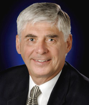
George J. Komar has over 38 years experience in engineering, program, project and operational management. Presently he serves as the Associate Director in the Earth Science Division and Program Manager for the Earth Science Technology Office (ESTO) for NASA. In this capacity he is responsible for developing, integrating and managing all the advanced technology developments that will enable future Earth Science capabilities.
He recently he served as the Deputy Associate Administrator for Technology for the NASA Science Mission Directorate (SMD), where he was responsible for planning, advocating, and optimizing an integrated advanced technology program. He was the Program Manager for the Landsat 7 Program and the TOPEX/Poseidon Program. George also managed the integration of the NASA Space Station Ground System Program for Space Station Freedom.
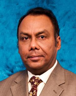
Murali S. Nair is a Program Director in the areas of Electronic Hardware, Robotics, and Wireless Technologies with the SBIR/STTR Program. Prior to joining NSF, he was the Founder CEO of a Bluetooth wireless product company. In this capacity, he raised equity capital for worldwide operations in the U.S., China and India. He designed, planned and implemented the product development cycle, and managed the marketing strategy, strategic alliances and business development processes. Before that, he was a Senior Systems Engineer at L-3 Communications where he provided strategic advice to the Executive VP for a complete re-plan of the Hughes contract for real-time, embedded ground control software for the $350M PANAMSAT communications satellite. Prior to joining L-3 Communications, he was a Mission Planner at Motorola Iridium where he was involved in all aspects of satellite operations including orbit determination, generating guidance targets and orbital slot placement. Before joining Iridium, he was a faculty member at Embry-Riddle Aeronautical University, where he developed an entire Space Systems Design Lab from concept inception to fully operational mode and national prominence, and supervised five (5) space system designs, three (3) of which were winners in the National AIAA/Loral Design Competition. He is a recipient of a number of awards including NSF’s second highest award for meritorious service and the President’s Innovation Award for Space Systems Design courses while at Embry-Riddle. Murali is a graduate of the Indian Institute of Technology and the University of Texas. He is a registered professional engineer in the State of Florida.
| TH4.TIE: GSIS Round Table: Imaging Spectroscopy from an Industry Perspective – State of the Art/Potential/Challenges |
|---|
| Session Type: Panel |
| Time: Thursday, July 27, 16:20 - 18:00 |
| Location: Room 200 |
| Session Chair: Andreas Müller |
Spaceborne Imaging Spectroscopy has long been recognized as an essential Earth observation technology for geoscientific research applications and Earth system sciences. The technology demonstrator mission Hyperion was operational in space for an impressive 16 years and, had stimulated a series of medium spatial resolution scientific missions such as HyspIRI in the USA, PRISMA in Italy, EnMAP in Germany, HISUI in Japan and a series of other initiatives around the globe. Despite both technical and financial challenges, much has been achieved including recent proposals of high spectral and spatial resolution spaceborne imaging spectroscopy by the private sector in USA, Canada, Japan, and Israel. Additionally, spaceborne imaging spectroscopy missions are now being considered as operational future missions by space agencies. But also imaging spectroscopy technologies in general has seen significant progress. For example, spectrometer systems have successfully been miniaturized and flown on drones and UAVs and there have been significant developments in available platforms with small/micro satellites.
In commemoration of the tenth anniversary of the GSIS TC, we would like to celebrate the achievements of the last 10 years and look forward to what might be the vision for the next 10 years. For example, the coupling of these developments to provide high spatial and high spectral resolution sensors onboard small satellites is an attractive proposition that could potentially make spaceborne imaging spectroscopy missions financially viable while closing gaps in spatial and temporal resolutions in the present suite of near-launch scientific missions.
Potential panel discussion items are:
Panelists and audience are encouraged to suggest key application scenarios where such sensors would fill niche information gaps with a high potential to justifying private and government investments and assure return on investment.
The event features:
David Bannon is co-founder and Chief Executive Officer of Headwall Photonics, responsible for shaping the Company’s vision and corporate direction. Through his entrepreneurial leadership, David has positioned Headwall as a worldwide provider of instrument-based spectral sensing solutions that touch many aspects of daily life. From precision agriculture and industrial food inspection to critical areas such as homeland security and military reconnaissance, David has helped bring the science of spectral imaging to new application areas and geographical regions while ushering in entirely new and affordable product categories.
David has authored numerous technology and application articles and has established key patents in the area of spectral imaging. He has also chaired industry association forums and often speaks to diverse audience groups on the topic of spectral sensing and imaging technology.
Active in the non-profit sector, David also sits on the Board of Trustees of the Foundation for Metrowest, a philanthropic organization based in Massachusetts.

Matthew Ferraro is an Applied R&D engineer at Planet. He has been with the company for 5 years and is a member of Planet's founding team.
During his tenure at Planet, he's helped build several of the company's critical technologies. Matt started designing embedded radio interfaces and bus communications for Planet's first-ever satellite builds—Doves 1 and 2. He later moved on to work on Planet's first mission control infrastructure and interfaces, before leading the development of Planet's automated Image Registration/Ortho-Rectification efforts. Now, as a member of the Applied R&D team, Matt investigates everything from machine learning and imagery change detection techniques to exotic spacecraft sensor technologies and advanced data visualization tools.
Before Planet, Matt worked on several projects as an intern at NASA Ames, notably the PhoneSat project. Matt received a Bachelor's degree in Aerospace Engineering from MIT.
At T-Systems Jurry de la Mar is working with European Institutions developing and implementing new ICT solutions, cloud computing and security solutions. Generating cost savings and improving productivity for public sector organizations and programs is in his focus. With T-Systems being one of the core service providers for the European Earth observation program Copernicus and Jurry coordinating their involvement he has a long experience on big Earth observation data distribution, storage and processing.
Jurry holds a PhD in Physics from the Free University Amsterdam and a degree (SEP) from the London Business School.
Prof. Dr. Steffen Kuntz has more than 30 years of experience in remote sensing applications and Geographic Information Systems. Working since 1993 in industry his activities included for instance product marketing and project management in Europe, the Near East, Russia, India, Indonesia, South America and Africa. He was responsible for the acquisition and management of various Earth observation and navigation application projects in the fields of forestry, agriculture, water management, land use planning, disaster management, illegal logging, communication, etc.
Joining Infoterra GmbH in 2002 he acted as Senior Advisor for geo-information services, and was responsible for market development, scientific studies and the management of large international projects, for instance in the framework of the European Copernicus initiative. From 2012 onwards he worked in the Corporate Development Department of Astrium GEO Information Services responsible for institutional relations and climate change programs. In June 2013 he moved to the Future Missions Department of Airbus Defence and Space in Friedrichshafen, to support end-to-end satellite development and related services and in satellite export programs.
In 1997 he was nominated Assistant Professor for Remote Sensing and GIS at the University of Freiburg, Faculty for Forestry and Natural Resources Management. In 2005 he became Associated Full Professor. In addition he gave master courses as guest lecturer at the University of Münster, Germany, in Greece at the Aristotle University of Thessaloniki and the Mediterranean Agronomic Institute of Chania, Crete and at the Universities of Paraná and Viçosa, Brazil.
Sean Anklam is the founder and Executive Director of Exogenesis Corporation in Boulder, CO. Sean’s vision for Exogenesis is to transform all earth observations into insight, with no human or manual software intervention between observation and product in real time. His research interests are fixated on new imaging modalities, artificial intelligence/machine learning, signals processing, computer vision, algorithm development, and creating globally fused datasets into structured and actionable information.
For more than five years Sean worked at SpecTIR as director of analytics and chief technical officer designing and deploying automated data fusion products primarily derived from hyperspectral imagery and marketing these products to commercial and government customers. Establishing and innovating spectral image processing best practices and training new employees in their use. He served as an Adviser to the National Intelligence Council at the Office of the Director of National Intelligence.
Sean holds a BS degree in Physics and a MS degree in Applied Physics and Mathematics from the Georg Mason University, Virginia.
Robert O. Green has been involved in environmental imaging spectroscopy research from 1983 to present including the AVIRIS program at Nasa JPL, Pasadena. He is science team member for 4 spaceborne and 5 airborne imaging spectrometers instruments and a PI of the decadal survey mission HyspIRI. His focus is on the end-to-end science requirements from science question to calibration to instrument to photons. Recent research activities include: spectroscopy of the three phases of water; snow and ice hydrology, wild fire measurement, ecology, atmospheric spectroscopy and radiative transfer; connection of instrument specification, characterization, calibration and validation to science and application objective.
Rob holds a PhD, in Spectroscopy of the Three Phases of Water from the University of California, Santa Barbara, an MSc and a BSc from Stanford University.